Picton is situated in a harbor off Queen Charlotte Sound and is one of the cutest towns (Loreen's term, and I totally agree) we have encountered. It is not an industrial port, it handles the trucks and containers that come across on the ferry from the north island and gets about three cruise ships a month. Consequently it has grown up as a bit of a tourist town and all the downtown streets end at the wharf. The wharf itself is full of little pubs, restaurants, small retail stores and tour companies. There was a junior sailing regatta taking place as we left the wharf, with these little boats going, to me, around in circles.
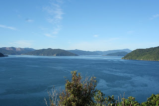
The north end of the south island is all sounds while the south end is all fjords. Being an inquisitive type I asked what the difference was. Fjords are caused by glacial gouging and movement while sounds are old river valleys. The total north east end of the south island was at one time inland lakes and rivers that have sank and been flooded by the ocean
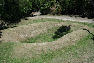
We visited a Maori "pa", which is a high piece of land that was supposedly easily defendable. This particular one was set on a high ridge with steep cliffs on three sides and a narrow strip of land into the main area. As there were no rats, etc, on NZ they simply dug ground pits in which to store enough food to last out a siege. This group was eventually wiped out by another band of Maori that had been supplied muskets by the British. No archaeology work has been done here and the site is maintained as it was found.
 |
| Food Storage Pit |
We then followed the old foot path down to the beach where there were hundreds of black and purple mussels attached to the rocks along the shore line. Loreen, being ever enterprising, decided we should gather up a sack of these for our supper. I was pretty skeptical about it all, without asking a local if they were safe to eat or not. Loreen won out and what the heck you have to take some risks, so we gathered a dozen of the biggest and took them back to camp. After a good cleaning we steamed them open and then grilled them on the half shell with copious amounts of garlic and butter. Yum, yum, why do I ever doubt my wife!
 |
| Beach Mussells |
Queen Charlotte Sound was named by Captain Cook after the Queen of England. Cook explored NZ from 1770 to 1777 and had favorite places in the sound where he would stop and replenish ship supplies and repair any damage. He established and claimed NZ as a British possession at a place now called Ships Cove. It is a sheltered cove with an abundance of fresh water and fish. Cook stopped there five times and planted fruit and vegetable gardens and off loaded sheep, pigs and chickens in the expectation that the plants would grow and animals multiply to provide food sources on subsequent trips. The Maori in the area, although friendly to Cook and his crews, must have been really happy every time he returned with another load of animals, as they ate all the vegetables and animals long before his return.
NZ has world class hiking and there is a 71km track along the ridge line of Queen Charlotte Sound. There is also a protected island just off Ships Cove where all predators have been removed. One must remember that NZ had no predators prior to European ships and the predators here now are hedgehogs, ferrets, possums, feral cats, etc, most brought by the English as pets and then let go into the wild. These animals have almost exterminated some NZ bird species, so this island was declared a protected area to recover the birds. Not active birders, we none the less, went out to the island to see some birds.
 |
| Weka, a NZ Flightless Bird |
All though we did see a few birds the real treat was being able to just stop and listen to the songs from the bird choir. It was like listening to one of those tranquil CDs that they sell in some shops. There was also a viewing tower that was above the canopy and provided a 360 view of the sound.
 |
| Queen Charlotte Sound |
After an hour on the island the boat returned and picked us up, took us across to Ships Cove and dropped us at the trail head of the Queen Charlotte track with the Captain informing us that if we made a 15 km hike to Furneaux Lodge, that the mail boat would be there in five hours and would take passengers back to Picton.
With the blisters mostly healed and feeling pretty smug about our last hike, we spent 30 minutes looking at all the memorials and information boards about Captain Cook and his voyages, then set off for the lodge. The first 2.25 kms was a 200 meter ascend to the top of the ridge and then another 2.25 kms back to sea level. The last 10.5 kms was a bit easier but still had many ascends and descends. We stopped twice to snack and made the hike in four hours, and even though the last kilometer was flat it seemed as hard as the first 2.25 kms. So with a half hour to spare we had a lay down on the beach and waited for the mail boat. They must have delivered a lot of mail that day as it was about forty minutes late, but it also picks up passengers and delivered us safe and sound back to Picton.
 |
| The Mail Boat |
After a Kilkenny, a Connemara, fish and chips and cottage pie, (not shepherds as shepherds pie has to be made with lamb and this was made with beef), we limped off to our trusty little home on wheels in preparation of crossing Cook Straight to the North Island. Well Loreen had the Kilkenny and fish and chips, I didn't have it all!

No comments:
Post a Comment